

Report by; Farid Kefel, for The Calabash Newspaper
Sierra Leone remains prone to serious environmental hazards such as drought, flooding, coastal erosion, and landslides, each of which is exacerbated by ongoing climate change. Climate projections in Sierra Leone include increases in temperature, more extreme weather, including more intense precipitation, and rising sea levels.
The likelihood of more severe droughts, floods, and storms threatens agriculture, fisheries, as well as infrastructure, and hydroelectric power production. Urban and rural seasonal flooding, recurrent flash flooding, and coastal flooding are the most frequently observed disasters. In the recent past, disasters have mostly happened in Kroo Bay, Susan’s Bay, and Lumley in the Western Urban district. Port Loko, Kambia, Western Rural, Pujehun, Bo, Kenema, and Moyamba districts and the coastal beaches of the Western Area Peninsula are also vulnerable. There are also trans boundary risks of overflows at the Great and Little Scarcies rivers from Guinea and Mano from Liberia (World Bank 2017). Floods overwhelm existing systems, contaminate drinking water, create sewage overflows, and damage roads.
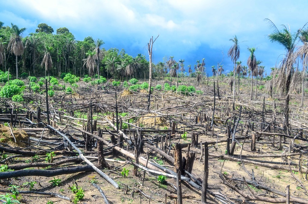
Deforestation of the Western Area Peninsular Forest Reserve (WAP FOR) poses a serious threat to Freetown as it is the catchment area for the Guma Valley reservoir, which supplies 90 percent of Freetown’s drinking water. In March 2022, WFP satellite images proved the loss of over 4,000 ha of trees. Despite a legal framework being in place to protect the reserve, unregulated human activity has contributed to WAPFOR’s decimation.
According to Global Forest Watch, within the last 4 weeks in Sierra Leone, 12,696 deforestation alerts were detected, which affected an area of approximately 155ha. The top 2 regions accounted for 84% of integrated deforestation alerts. In Sierra Leone, the top 2 regions were responsible for 73% of all tree cover loss between 2001 and 2021. Southern had the most tree cover loss at 688kha compared to an average of 455kha. From 2001 to 2021, Sierra Leone lost 1.82Mha of relative tree cover, equivalent to a 32% decrease since 2000 and 0.42% of the global total. According to the FAO, the rate of reforestation in Sierra Leone was 343ha per year in 2010. In Sierra Leone between 2000 and 2020, 100% of tree cover gain occurred outside of plantations. From 2002 to 2021, Sierra Leone lost 32.7kha of humid primary forest, making up 1.8% of its total tree cover loss in the same period.
Sierra Leone is endowed with 690,000 hectares of inland valley swamps (IVS) that, managed effectively, can provide agricultural yields for food self-sufficiency in the country. Through its food-assistance-for-assets program and other incentives, WFP collaborates with the Ministry of Agriculture to draw small-scale farmers away from the uplands, where deforestation is rampant and yields are low, to the IVS. With year-round water availability and fertile soils that do not require fallow periods, irrigated IVS provides a high-potential food production system that can be continuously cultivated with rice and nutritious vegetables, legumes, and tubers.
Given the increasing rainfall variations and deforestation, irrigated IVS provides a more resilient food production system to both adapt to and militate against the effects of the climate crisis. WFP and the Ministry assist 140 groups comprised of over 7,500 farmers across seven districts to cultivate the IVS. A large percentage of the farmers are women and youth, whom the Ministry trains in integrated farming techniques for higher yields (average of 2.4 metric tons/hectare). WFP also provides good seeds and fertilizers.
A common threat to Freetown is the rapid rate of urbanization, coupled with the increased rate of deforestation. The area where the landslide occurred was within a protected forestry reserve. However, over time, the development of large houses occurred some illegally (without permits) and some with permits (legally). And because of these two factors – housing development and deforestation – soil integrity was weakened and the ability to absorb rain during high rainfall increased the risk of disaster. Access to an improved water source does not indicate whether the water supply is continuous. For example, in Freetown taps were running dry for most of the year in 2009, and still happening in 2022.
People collected water in containers wherever they can and those who can afford it installed water tanks in their houses. Even the fire brigade used its trucks to sell drinking water. There were fights between fire fighters and employees of the Guma Water Company, responsible for water supply in Freetown, sometimes resulting in deaths. Evidence is clear that climate change is changing weather patterns, and increasing the frequencies and intensities of extreme weather events. Unfortunately, those in the poorest communities are disproportionately affected.