

Report by; Farid Kefel, for the Calabash Newspaper
Sierra Leone remains prone to serious environmental hazards such as drought, flooding, coastal erosion, and landslides, each of which is exacerbated by ongoing climate change. Climate projections in Sierra Leone include increases in temperature, more extreme weather, including more intense precipitation, and rising sea levels.
The likelihood of more severe droughts, floods, and storms threatens agriculture, fisheries, as well as infrastructure, and hydroelectric power production. Urban and rural seasonal flooding, recurrent flash flooding, and coastal flooding are the most frequently observed disasters. In the recent past, disasters have mostly happened in Kroo Bay, Susan’s Bay, and Lumley in the Western Urban district. Port Loko, Kambia, Western Rural, Pujehun, Bo, Kenema, and Moyamba districts and the coastal beaches of the Western Area Peninsula are also vulnerable. There are also transboundary risks of overflows at the Great and Little Scarcies rivers from Guinea and Mano from Liberia (World Bank 2017). Floods overwhelm existing systems, contaminate drinking water, create sewage overflows, and damage roads.
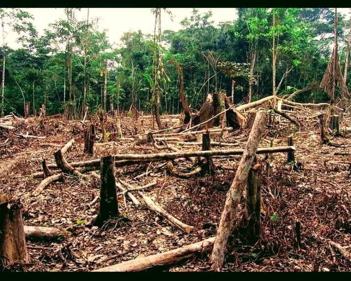
Deforestation of the Western Area Peninsular Forest Reserve (WAP FOR) poses a serious threat to Freetown as it is the catchment area for the Guma Valley reservoir, which supplies 90 percent of Freetown’s drinking water. In March 2022, WFP satellite images proved the loss of over 4,000 ha of trees. Despite a legal framework being in place to protect the reserve, unregulated human activity has contributed to WAPFOR’s decimation. Freetown’s equatorial climate barely varies throughout the year. Even within 24 hours, most days are hot and the nights are warm and most residents have no air-conditioning. This means that the working residents of the Sierra Leonean capital are continuously exposed to high temperatures, according to the Arsht Rock study. Without corrective measures, by 2050, economic losses will rise to the equivalent of USD 150 million. Deforestation due to rural-urban migration exacerbates overheating. What makes Freetown’s economy vulnerable is its overreliance on labor-intensive production. While active cooling, such as air-conditioning, can produce additional greenhouse gas emissions, it also provides strong protection from heat. As most workers survive on low incomes, this lost value has a disproportionate impact on individuals’ well-being and ability to escape hunger.
According to Global Forest Watch, within the last 4 weeks in Sierra Leone, 12,696 deforestation alerts were detected, which affected an area of approximately 155ha. The top 2 regions accounted for 84% of integrated deforestation alerts. In Sierra Leone, the top 2 regions were responsible for 73% of all tree cover loss between 2001 and 2021. Southern had the most tree cover loss at 688kha compared to an average of 455kha. From 2001 to 2021, Sierra Leone lost 1.82Mha of relative tree cover, equivalent to a 32% decrease since 2000 and 0.42% of the global total. According to the FAO, the rate of reforestation in Sierra Leone was 343ha per year in 2010. In Sierra Leone between 2000 and 2020, 100% of tree cover gain occurred outside of plantations. From 2002 to 2021, Sierra Leone lost 32.7kha of humid primary forest, making up 1.8% of its total tree cover loss in the same period. The total area of humid primary forest in Sierra Leone decreased by 12% in this period.
Sierra Leone is endowed with 690,000 hectares of inland valley swamps (IVS) that, managed effectively, can provide agricultural yields for food self-sufficiency in the country. Through its food-assistance-for-assets program and other incentives, WFP collaborates with the Ministry of Agriculture to draw small-scale farmers away from the uplands, where deforestation is rampant and yields are low, to the IVS. With year-round water availability and fertile soils that do not require fallow periods, irrigated IVS provides a high-potential food production system that can be continuously cultivated with rice and nutritious vegetables, legumes, and tubers. Given the increasing rainfall variations and deforestation, irrigated IVS provides a more resilient food production system to both adapt to and militate against the effects of the climate crisis. WFP and the Ministry assist 140 groups comprised of over 7,500 farmers across seven districts to cultivate the IVS. A large percentage of the farmers are women and youth, whom the Ministry trains in integrated farming techniques for higher yields (average of 2.4 metric tons/hectare). WFP also provides good seeds and fertilizers.
Evidence is clear that climate change is changing weather patterns, and increasing the frequencies and intensities of extreme weather events. Unfortunately, those in the poorest communities are disproportionately affected. On August 14, 2017, a devastating landslide and flooding disaster ripped through Sierra Leone’s capital city, Freetown. This caused millions of dollars of destruction and damage to buildings, infrastructure, and a reported loss of more than a thousand lives. In response, the government of Sierra Leone requested financial and disaster risk management support from the World Bank should such an event reoccur. Before the landslide, Freetown experienced three successive days of intense and heavy rainfall which caused part of Sugar Loaf mountain – the highest peak in the North Western Area Peninsula – to collapse, and with bodies being washed up on the beaches, and bridges connecting communities and water distributions networks destroyed, response efforts spanning several sectors required millions of dollars to address the direct losses from the disaster. However, this still left the citizens of Freetown extremely exposed and vulnerable to future disasters. A key consideration in post-disaster planning is to ensure that build-back better principles are well considered and integrated so that nobody is left behind during the reconstruction efforts. And engineers, architects, and designers are fundamental in ensuring that appropriate design measures are fully integrated and calculated using accurate data sets. After the landslide, the World Bank, Global Facility for Disaster Reduction and Recovery (GFDRR), and the European Union commissioned analytical studies of the landslide and geology of surrounding areas. While there was no single cause for the landslide, there were many contributing factors.
A common threat to Freetown is the rapid rate of urbanization, coupled with the increased rate of deforestation. The area where the landslide occurred was within a protected forestry reserve. However, over time, the development of large houses occurred some illegally (without permits) and some with permits (legally). And because of these two factors – housing development and deforestation – soil integrity was weakened and the ability to absorb rain during high rainfall increased the risk of disaster. Presented with the analysis of the landslide disaster, the president of Sierra Leone Dr. Julius Maada Bio declared that the landslide area is to be re-designated as a protected forest area – a memorial park for those that lost their lives during the disaster. The first locally sourced saplings were planted to mark World Environment Day with a total of 30,000 trees making up the memorial park in the hopes that this symbolic memorial park would deter settlements from being built. Over the past decades, Sierra Leone has experienced multiple man-made and natural disasters. In the past ten years alone, the country has suffered significant outbreaks of preventable diseases including cholera and measles, as well as a regional epidemic of the deadly Ebola Virus Disease (EVD), which lasted two years and infected more than 8,000 people in the country, killing an estimated 3,500. According to the World Health Organization, that number includes more than 150 health workers who lost their lives – representing a serious blow to the country’s healthcare system, which continues to struggle to meet the needs of the nation.
In 2017, torrential rains led to a mudslide on the outskirts of the capital city, Freetown, which killed more than 500 people and displaced 3,000 more. While the mudslide was directly triggered by heavy downpours – a common occurrence during the country’s annual six-month-long rainy season – the tragic event was also largely contributed to by rapid urbanization, illegal and haphazard housing development, and deforestation. Particularly in the country’s urban centers, each of these issues is becoming increasingly common and poses considerable threats to inhabitants in years to come. Similarly, in 2019, multiple flooding incidents occurred in six districts across Sierra Leone, which damaged homes and temporarily displaced several thousand households, contaminated water sources, and inundated rice paddies in Sierra Leone’s ‘rice belt’ region – carrying significant longer-term implications for food security. Nationwide, high poverty levels, ongoing food insecurity issues, and shocks from previous emergencies leave many children and their families especially vulnerable to future disasters and disease outbreaks.
Sierra Leone is endowed with abundant water resources, including seven major rivers: the Kolenté (Great Scarcies), Kaba, Rokel, Pampanga (Jong), Sewa, Moa, and Mano. There are substantial groundwater resources. However, water is scarce during the dry season: only 11-17 percent of the annual river discharge occurs between December and April, with minimum discharge in April. The main source of piped water for Greater Freetown, an urban agglomeration of about two million, is the Guma dam located in the Western Area Forest Reserve. It supplies 83 million liters a day entering the city from the West where the more affluent areas are located. A new dam, the Orugu dam, would provide an additional 75 million liters per day in its initial phase, entering the city from the East where the poorest areas are located. According to a study by the consulting firm Atkins and Oxfam the dam “is the answer to the water supply crisis in Freetown”. In 2009 the Chinese government announced it would provide a US$28.8 million concessional loan to build the dam. In Sierra Leone, according to a national survey (Multiple Indicator Cluster Survey) carried out in 2006, 84% of the urban population and 32% of the rural population had access to an improved water source. Those with access to rural areas were served almost exclusively by protected wells. The 68% of the rural population without access to an improved water source relied on surface water (50%), unprotected wells (9%), and unprotected springs (9%). 20% of the urban population and 1% of the rural population had access to piped drinking water in their home. Since national household surveys are not carried out on an annual basis, more recent survey data than those of 2006 were not available as of March 2010. Compared to the 2000 survey access has increased in urban areas, but has declined in rural areas, possibly because facilities have broken down because of a lack of maintenance.
Access to an improved water source does not indicate whether the water supply is continuous. For example, in Freetown taps were running dry for most of the year in 2009, and still happening in 2022. People collected water in containers wherever they can and those who can afford it installed water tanks in their houses. Even the fire brigade used its trucks to sell drinking water. There were fights between firefighters and employees of the Guma Water Company, responsible for water supply in Freetown, sometimes resulting in deaths.
The water supply in Sierra Leone is characterized by limited access to safe drinking water. Despite efforts by the government and numerous non-governmental organizations, access has not much improved since the end of the Sierra Leone Civil War in 2002, stagnating at about 50% and even declining in rural areas in Salone. According to the numbers released by JMP in 2017, 58% of the population has access to at least basic water and 15% of the population has access to at least basic sanitation. However, estimating the number of people with access to safe drinking water in a developing country is a challenging task. Since drinking water quality is typically not tested regularly for a representative sample of households throughout the entire country, there are no reliable data on the share of drinking water that is safe. National household surveys typically ask questions about the type of water source used. House connections, yard connections, standpipes, and hand pumps that are located within 1 km are classified as what is called an improved water source. Open wells, unprotected springs, rivers, lakes, and ponds are not considered improved water sources
In the capital Freetown, taps often run dry. It is hoped that a new dam in Orange, for which China committed financing in 2009, will alleviate water scarcity. With a new decentralization policy, embodied in the Local Government Act of 2004, responsibility for water supply in areas outside the capital was passed from the central government to local councils. In Freetown, the Guma Valley Water Company remains in charge of the water supply. A 2005 report says that wide-scale corruption is a major problem in the sector. It continues to say that there is a lack of trust between non-governmental organizations (NGOs) and the public water company Salwaco, which was “suspicious to NGOs”. A decision by Salwaco to use only German Kardia hand pumps was controversial since they are more than twice as expensive as the India Mark II pumps preferred by many NGOs.
It must be noted that the Guma Valley Water Company relies principally on that single source, the Guma Dam and the Guma Water Treatment Plant at Mile 13, with over 90% of the total water supply to over 1.5 million people in the capital city of Freetown, and on the 23rd of April 2022, President Julius Maada Bio, visited the Guma Valley Dam at Mile 13, where he saw firsthand and with shock how the environment has faced massive encroachment and called for the re-establishment of the Western Area Forest Green Belt and an immediate investigation into the activities of the Ministry of Lands and Housing for the concerning environmental infractions. The President’s visit was geared toward seeing the enormity of the threat to the water source and providing the required political leadership to lawfully prosecute and punish deforestation and those involved in land grabbing around the water catchment areas. The ongoing encroachment of the Western Area Forest Green Belt area of the Guma Valley Dam facility is an environmental concern that should be stopped immediately. Salone parliament implemented The Western Area Forest Green Belt area. The land is protected by law. This is very annoying and concerning. The law stated that encroachers and land grabbers will be persecuted in all forms of the law as agreed in parliament as it is an existential threat that will not be tolerated. The president highlighted that the notion was to re-establish the Green Belt and protect it,” as emphasized furiously by the president.


